|
Tue 10 May
2011
The History of Maps in North West England by Dr Ian Saunders |
|
One of the most
useful sources for local historians is local maps and Dr
Saunders took us through the many stages in the development of
the map from 14th century maps drawn on velum to the accurate
maps of the 19th century. Although he is from Lancaster
University his department isn’t history but physics. He started
his love of maps in 1984 when he bought his first antique map.
The earliest map depicting England dates from around 1350 and
was drawn on calfskin or velum with east at the top. The first
printed maps appeared around 1540 (Cosmographia by Sebastian
Münster) but as they were from woodcuts the detail was fairly
crude. The first detailed map of Lancashire was Saxton’s of
1577. It shows Chorley as Charley and this miss-spelling was
carried through to many subsequent maps that followed. It is
orientated with magnetic north to the top which hadn’t been the
case previously. Mapmakers would go for the best fit on a sheet
of paper and north was usually shown to the left. All maps were
printed black and white up to 1850s and any colouring was done
by hand. Abraham Ortelius (1527 – 1598) a Flemish cartographer
and geographer who used to specialise in colouring maps along with
his sister. He was the first to have the idea of printing an
atlas, a book of maps all prepared to the same design and style.
The mapping information came from Gerardus Mercator (1512 –
1594) who was a cartographer born in the County of Flander.
Mercator also produced an atlas but Ortelius had called his
atlas a theatre. For a hundred years the two names were
interchangeable but eventually the name atlas won. |
 |
|

Dr Ian Saunders |
|

Abraham Ortelius (1527 – 1598) |

Gerard Mercator (1512 – 1594) |
|
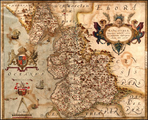
The Sexton Lancashire map of 1577 |
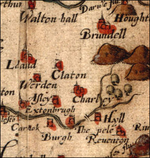
A detail from Sexton's map showing the
incorrect spelling of Chorley as Charley. |
|
As maps needed
to be updated the original engraved copper plate that was used
for the printing had to be altered. This was done by lightly
hammering the back to raise the front printing area, polish it
down flat, and then re-engrave it. Saxton’s 1577 map was about 5
miles to one inch.
Speed’s map of 1610 was based on the Saxton map but some extra
details were included such as illustrations of heads of the
houses of Lancaster.
In 1644 the first folding map was produced and sold by Thomas
Jenner, primarily as an aid for the commanders in the English
Civil War. |
|
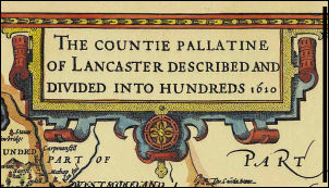
The title from Speed's map of 1610 |

Speed's map still shows Charley! |
|
There are 52
counties in England and Wales and 52 cards in a pack of cards.
One set was produced in 1676 with one county per card and even
showed roads.
|

The 1676 playing card map of Westmorland |
|

The first folding map of 1644 produced
and sold by Thomas Jenner |
|
John Ogilby
(1600 - 1676) was a Scottish cartographer who produced the first
detailed road maps, accurately surveying 8,000 miles of roads
around 1675. A 61 inch dia wheel was used to measure the
distances. A scale of 1inch to the mile was used for the first
time. The statute mile of 1,760 yards had been established by
the Elizabethan Government then mostly ignored. In 1719 a
reduced version of the road map was produced by Emanuel Bowen
and had reference to Chorley with the correct spelling.
The miss-spelling of place names was fairly common from early
times through Saxton (1577), Speed (1610) and Morden (1695). A
new map would often be partially copied from earlier versions by
somebody else. The copyright laws as we know them didn’t exist. |

A surveyor and measuring wheel |

Title detail from the Yates map of 1787 |

Yates shows Chorley correctly in 1787 |
|
The
first major improvement of Saxton’s map was one by
Emanuel Bowen in 1752.
Richard Towneley (1629 – 1707)
was an English mathematician and astronomer from
Towneley near Burnley and he used astronomical
observation to fix the position of Towneley, only the
second place to be so fixed after Greenwich. Thomas
Kitchin produced a map in 1752 using the same
astronomical principles but it wasn’t always successful.
In 1787/8 the next major improvement happened with the
maps of William Yates which were engraved by Thomas Billinge. The maps were based on a triangulation survey.
Christopher and John Greenwood surveyed Yorkshire in
1817 and Lancashire in 1818 increasing the detail
further. They hoped to complete the whole of England but
failed.
The George Hennet map of Lancashire came out in 1830. He
was involved in Railway survey work but eventually went
bankrupt. |

Greenwood's Map of 1818 |
|
| |
|
|
Robert Louise Stevenson drew a fictitious map for his own
amusement and found it so interesting he wrote a book about it
‘Treasure Island’. The manuscript and map were sent to the
publisher but they lost map and Stevenson had to recreate it
from the book which he found harder than writing the book from
the map. He said that maps were:
‘an inexhaustible fund of interest for any man with eyes to see
or twopence-worth of imagination to understand with!’
BH |

The map which has appeared in every edition of Treasure Island
since its first appearance in book form in 1883 |
|
|