|
Tue 10 May 2016
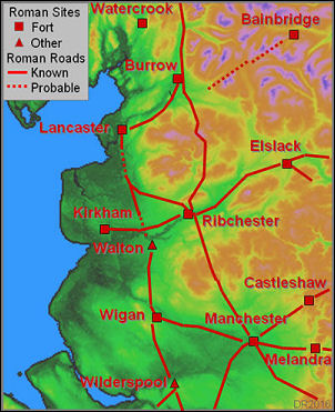
Roman Roads in Lancashire – David Ratledge |
|
|
David was given a warm reception by a
large attendance that reflects the popularity of the subject
matter. He explained that his talk on Roman roads is based on
new discoveries using technology that uses light sensors to
measure distance between the sensor and a target called Light
Detection and Ranging (LIDAR). It is operated from an aircraft
and has been used by the Environment Agency, which it has used
it in its flood defence work.
Starting with
an image of a cross section of a Roman road David explained the
road’s construction meant it would be raised above the
surrounding ground. Identification of these roads was based good
old fashioned excavation. However, where there were gaps in the
knowledge of a road’s route other clues were used, such as place
names and conjecture on where a road would have ran. Ordnance
Survey (OS) maps showed lines of some Roman roads that were
based on nothing more than this basis |

David Ratledge |
|
LIDAR is able to measure height of ground to differences of 2
inches. Consequently, subtle changes to ground heights invisible
to the naked eye and photography, even from above, are
identified.
Up to 70% of Lancashire has been covered by
LIDAR and because of research done by David and others, lines of
some of its Roman roads have been changed.
Particular
attention was paid to certain sections of Roman roads in the
county that are shown on OS maps but had puzzled David.
With LIDARs 3-D digital surface images David showed the
Lancaster-Preston, north-south ‘coastal’ road, is seen to run
through Cockerham, which was previously unknown.
Another
puzzled solved was the road east of Lancaster to Caton. The line
previously thought to be that of the Roman road proved to be
incorrect. |
Roman Roads |
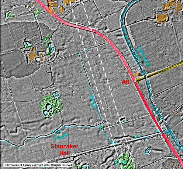
The key piece of evidence for the
route just south of Garstang.
The LIDAR image of the route can be
clearly seen. |
|
The ‘inland’
north-south road from Lancaster to Ribchester was generally
thought to have run over the Bowland fells. However, LIDAR
evidence shows the road leaves the Lancaster-Preston road at
Catterall, near Garstang before cutting south east past Brock
and Longridge then down to Ribchester.
The line of a Roman road, marked on OS
maps as ‘Danes Pad’, was long believed to have run west of
Kirkham. LIDAR has found no supporting evidence of any Roman
road west of Kirkham.
The many
images David showed and his narrative proved to be totally
absorbing for all those present. He concluded that much of what
he said has yet to be published online so was hot off the press.
He now intends to concentrate on Roman roads in Cumbria.
These recent
developments using LIDAR will be a great help to archaeologists
and was, without doubt, of great interest to all of those
present that evening.
David has updated an excellent website
on some of his findings. You can see it via the link below:
http://www.romanroads.org/gazetteer/lancspages.html
Peter Robinson |
|


